
One of Antarctica’s most amazing features is a hidden network of streams, rivers, and freshwater lakes beneath its ice sheet, stretching across the entire continent. All this water eventually flows downhill into the ocean (see Figure 1).
The presence of this hidden system beneath Antarctica’s two-mile-thick ice sheet is perhaps the most compelling evidence that geological forces shape nearly every aspect of the continent and its surrounding oceans.

Many research studies (e.g., here) confirm what has long been proposed: a liquid river and lake system exists beneath the entire Antarctic continent. The presence of this hidden water network carries significant implications for the validity of climate change theory.
From Eos:
“In Antarctica, beneath the ice, there is liquid water—and potentially a lot of it. That’s the takeaway from new research that used seismographic instruments to probe the still largely unstudied boundary between Antarctica’s bedrock and its ice sheet.
“Previous hydrological studies and modeling work have found evidence of lakes and rivers beneath the Antarctic Ice Sheet, though much remains unknown about the region.”
Here are more studies documenting these freshwater rivers and lakes beneath Antarctica’s ice sheet (see here, here, here, here, here, and here).
The average yearly atmospheric temperature in Antarctica is -45°F, ruling out atmospheric heat as a source for the water that feeds the continent’s actively flowing rivers and lakes.
Ocean water exists beneath only a tiny fraction of the ice sheet. Some have theorized that it could warm and melt large portions of the glacial ice, but the actual area affected is far too small to account for significant ice melt.
Finally, friction melting has been proposed as another process that could generate enough water to feed the rivers and lakes. This occurs when the weight of the ice sheet presses down on the rock beneath, causing ice crystals at the base to melt.
The scientific community notes that this idea is still in its early research stages and is therefore highly unlikely to be valid.
The only remaining theory for what melts enough ice to supply the rivers and lakes is geothermal heat.

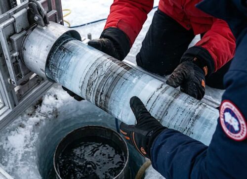
A striking example of a massive lake buried deep beneath Antarctica’s ice sheet is Lake Vostok (see Figure 2). Its surface lies about two-and-a-half miles below the ice, stretching 160 miles long and 30 miles wide—covering roughly 4,000 square miles.
Most scientists believe the lake formed from volcanic activity that melted part of the overlying ice sheet.
Russian scientists drilled into the lake and discovered unfrozen water, living organisms, and proof of geologically generated geysers on the lake floor, which emit warm fluid.
This warm fluid keeps part of the lake water unfrozen (see Figure 2). Researchers monitoring the height of Lake Vostok’s ice cover observed something truly remarkable: occasionally, the ice covering the lake rapidly and measurably drops, only for the lake to later rise back to its original level.
This phenomenon is called “flash draining.” When the lake reaches its highest level, and the river continues pushing water in, the ice-enclosed volume of liquid suddenly surges into the downstream river, partially draining the lake. Over time, ice dams form at the bottom of the outflow, allowing the lake to rise again to its peak level.
Geological Impacts on Sea Ice

Figure 3 juxtaposes two maps: on the right, the fifty-year average of ocean temperatures surrounding Antarctica; on the left, the average loss of Antarctic sea ice in 2024. In the right image, the anomalously high–temperature ocean region is shown in red, while the anomalously melted sea ice region on the left is also shown in red.
The warm water is melting the overlying sea ice. This region of warmed water is generated by geological forces.
The water that fills the continent-wide, actively flowing river and lake system is created when heat emitted from rock layers melts the bottom of the glacial ice sheet. As these rivers flow toward the sea, they must be continuously warmed, or they would freeze and stop flowing.
Research has shown that most of the rivers beneath the ice in West Antarctica do reach the sea, indicating that their water remains at a relatively high temperature. This warm water, in turn, warms the surrounding ocean and melts the sea ice.
The diminished extent of ice off the coast of West Antarctica has also affected marine life in the region. These effects have been incorrectly attributed to the melting of sea ice caused by human-induced climate change.

The impact geological forces have on marine life is incredibly underestimated. One example is how geologically induced melting of sea ice off the coast of West Antarctica is affecting both penguins and a shrimp-like creature called krill.
The Bellingshausen Sea, as shown in Figure 4, was the focus of a recent research studysee here).
It stated:
“Emperor penguins are the only penguin species that breed during the Antarctic winter. During this time, they rely on stable sea-ice to lay their eggs and raise their young. As regional temperatures rise, the break-up of sea-ice during the spring season is happening earlier. This can be fatal for chicks that have not yet developed their adult waterproof feathers or learned to swim.
“This is exactly what happened in late 2022 – a significant reduction in sea-ice in the Bellingshausen Sea was the cause of catastrophic breeding failure across four colonies, resulting in the death of thousands of chicks.”
It also stated:
“At the heart of the Antarctic food web lies a tiny, yet mighty, organism known as krill. These shrimp-like creatures are the primary food source for countless species, including penguins, seals, and whales. Antarctic krill also provide an important ecosystem function for our planet – each year, they capture millions of tonnes of carbon and transport it for safe storage in the ocean, which helps to maintain stable climatic conditions. Krill rely on undersea-ice habitats during key phases of their life cycle, especially during the larval stages, for food and refuge from predators. Krill populations have already been found to be declining in some regions around the Antarctic Peninsula,4 and projections indicate that krill abundance could decline by over 40% by the end of the century in areas such as the North Scotia Sea.” (Both quote credits Emily Grilly, WWF Antarctic Conservation Manager).
Summary

The Antarctic continent is larger than the lower forty-eight states (see Figure 5). Abundant evidence indicates the presence of a subglacial freshwater system of streams, rivers, and lakes that covers nearly the entire continent. Based on available information, data, and observations, the water in this system flows downhill into the ocean.
Clearly, there is only one way Antarctica’s subglacial water system was formed and is maintained: heat emitted from the rocks beneath the ice sheet.
Bio
James Edward Kamis is a retired geologist with nearly five decades of hands-on experience studying Earth’s forces. With a B.S. in Geology from Northern Illinois University (1973) and an M.S. from Idaho State University (1976), he has spent his career uncovering how geological forces shape—and sometimes drive—climate and climate events. Kamis shares his insights in detail at the Plate Climatology Theory website and in his latest book, Geological Impacts on Climate.
Top photo: Panoramic view of Mount Melbourne, Antarctica, by Una Miller on Unsplash.


“Clearly, there is only one way Antarctica’s subglacial water system was formed and is maintained: heat emitted from the rocks beneath the ice sheet.”
There isn’t just one way; Antarctica’s vast subglacial water system forms from a combination of geothermal heat, the insulating effect of thick ice, pressure melting due to ice weight, basal friction, and surface meltwater penetrating down, creating interconnected lakes and rivers that influence ice flow and host unique ecosystems.
Many glaciers, particularly large ice sheets and fast-moving “warm-based” glaciers, have liquid water at their base, though the amount and state (flowing streams vs. trapped pockets) vary significantly.
The Fragile Earth and Delicate Balance of Nature are probably the two biggest lies we have gotten from the Eco-Freaks and The Delicate Balanced f nature is one of the oldest lies they have told us