
Research shows that most, if not all, of Greenland is underlain by an actively flowing, interconnected network of subglacial streams, rivers, and lakes (see right-side image in Figure 1).
This network spans roughly 900,000 square miles and appears to have been formed—and maintained—by intense heat flow from a variety of subglacial geological features, most prominently the faults of the Central Valley Fault and Rift System.
The volume of meltwater exiting Greenland’s ice sheet through its marginal rivers is immense—far exceeding what could be explained by atmospheric warming alone. This strongly indicates that widespread geothermal heat from the bedrock beneath the ice sheet’s interior plays a major role in driving basal melting.
1,000-Mile-Long Subglacial River
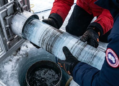
Researchers have identified a 1,000-mile-long subglacial freshwater river beneath Greenland’s ice sheet composed of hundreds of interconnected streams and lakes (see Figures 2 and 3; Strok, 2015). This river eventually drains into the ocean along Greenland’s northern edge.
Heat from a deep-earth lava pocket beneath the bedrock melts the overlying glacial ice, supplying a continuous source of water to the system.
Multiple studies have confirmed elevated subglacial heat flow originating from bedrock beneath the central Greenland Ice Sheet.
“The Northeast Greenland Ice Stream (NEGIS) currently drains more than 10% of the Greenland Ice Sheet area and has recently undergone significant dynamic changes. It is therefore critical to accurately represent this feature when assessing the future contribution of Greenland to sea level rise. At present, NEGIS is reproduced in ice sheet models by inferring basal conditions using observed surface velocities. This approach helps estimate conditions at the base of the ice sheet but cannot be used to estimate the evolution of basal drag in time, so it is not a good representation of the evolution of the ice sheet in future climate warming scenarios. NEGIS is suggested to be initiated by a geothermal heat flux anomaly close to the ice divide, left behind by the movement of Greenland over the Icelandic plume. However, the heat flux underneath the ice sheet is largely unknown, except for a few direct measurements from deep ice core drill sites. Using the Ice Sheet System Model (ISSM), with ice dynamics coupled to a subglacial hydrology model, we investigate the possibility of initiating NEGIS by inserting heat flux anomalies with various locations and intensities. In our model experiment, a minimum heat flux value of 970 mW m−2 located close to the East Greenland Ice-core Project (EGRIP) is required locally to reproduce the observed NEGIS velocities, giving basal melt rates consistent with previous estimates. The value cannot be attributed to geothermal heat flux alone and we suggest hydrothermal circulation as a potential explanation for the high local heat flux. By including high heat flux and the effect of water on sliding, we successfully reproduce the main characteristics of NEGIS in an ice sheet model without using data assimilation” (Smith-Johnsen et al, 2020).
Heat-conductive flux (HCF) emitted from subglacial bedrock appears to be the cause of basal ice melting and the generation of freshwater that feeds the 1,000-mile-long river system beneath Greenland, along with its associated streams and lakes.
Evidence indicates that this present-day high heat flow originates from the Greenland Central Valley Fault — a fault system that is currently active.
Many scientists have claimed that the subglacial bedrock heat was emplaced 80 to 50 million years ago and has since remained trapped, a condition known as remnant heat. However, the evidence suggests otherwise. The heat is not residual; it is actively being emitted from the Greenland Central Valley Fault System.
Major parallel faults of comparable length on both sides of the central valley further support this conclusion, as they also appear to be releasing significant amounts of HCF today.


The path of the subglacial river system closely follows Greenland’s northward movement over the stationary Greenland–Iceland Mantle Plume (see Figure 1). The river’s course aligns precisely with the faults associated with Greenland’s Central Valley Rift System.
Lakes
Greenland contains hundreds of subglacial lakes, many located beneath nearly 5,000 feet of ice. This provides strong evidence that these lakes were not formed, nor are they sustained, by a globally warmed atmosphere.
Supposedly Isolated Lakes
Recent research identified approximately fifty-four subglacial lakes beneath Greenland’s vast ice sheet (Bowling, June 26, 2019). The study attributed their formation to several factors, most notably geothermal high-bedrock heat flow, described by the authors as enhanced geothermal heat flux.
However, the evidence points to geothermal heat flux as the primary — and likely sole — driver behind the formation and maintenance of these subglacial lakes and their connected streams (see Figure 4).

The researchers described several of the subglacial lakes as “isolated,” meaning they were believed not to connect with the established network of subglacial rivers and streams. However, evidence suggests that these so-called isolated lakes are, in fact, part of Greenland’s broader subglacial hydrological system.
Study illustrations show numerous streams in areas surrounding the supposedly isolated lakes. Given the presence of intense geothermal heat directly beneath these sites, it is reasonable to conclude that connecting streams are necessary to drain the continuous production of meltwater (see Figure 4).
Greenland–Iceland Mantle Plume
The hatched black line in Figure 5, compiled by NASA scientists, illustrates the northwest movement of Greenland and Iceland across a stationary deep-earth Mantle Plume, also referred to as a Hot Lava Pocket (Martos, August 1, 2018).
This map shows that the current bedrock heat beneath the Greenland ice sheet corresponds closely with Greenland’s historical path over the stationary Mantle Plume.

Based on this correlation, NASA and other researchers concluded that the north-to-south trend of high heat shown in Figure 1 above is not the result of heat emitted by active faults. Instead, it’s believed the heat has remained trapped within the bedrock for 100 to 50 million years, originating from the ancient Mantle Plume.
This theory is incorrect for the following reasons:
- Numerous studies show that ancient heated bedrock zones rapidly lose their heat once the original heat source is no longer active.
- Regions with abnormally high bedrock heat compared to surrounding areas of the same age are the result of present-day heating from active geological features.
- Greenland is bordered to the east and west by two parallel, 1,000-mile-long ocean floor fault systems. Multiple studies confirm that these systems are currently highly active. They contain hundreds of submarine geyser complexes, several erupting or mildly erupting volcanoes, and numerous heat-emitting fault segments. These two fault systems share the same orientation and length as another long, linear subglacial fault system that runs through Greenland’s Central Valley low trend. This is compelling evidence that the present-day band of high heat values in the Central Valley is not a relic. (See the section on Greenland’s 1,000-mile-long subglacial river for more detail on the Central Valley Fault System.)
- The distribution of high bedrock heat along this trend does not decline evenly in proportion to Greenland’s steady movement across the Mantle Plume. As shown in Figure 55, distinct heat segments display uniformly higher or lower values than their neighbors. This pattern results from varying heat emissions within fault-bounded segments of the Central Valley Fault and Rift System. Some of these faults extend deep enough into Earth’s crust to tap into underlying hot lava pockets.

Summary
Research demonstrates that most, if not all, of Greenland is underlain by an actively flowing, interconnected network of subglacial streams, rivers, and lakes, covering roughly 900,000 square miles.
Evidence indicates that this network was formed and continues to be maintained by substantial heat flow emitted from numerous subglacial geological features, most prominently the faults of the Central Valley Fault and Rift System.
About the author
James Edward Kamis is a retired geologist with nearly five decades of hands-on experience studying Earth’s forces. With a B.S. in Geology from Northern Illinois University (1973) and an M.S. from Idaho State University (1976), he has spent his career uncovering how geological forces shape—and sometimes drive—climate and climate events. Kamis shares his insights in detail at the Plate Climatology Theory website and in his latest book, Geological Impacts on Climate.


A little more than 20 years ago I was watching a nature show about Greenland and they were talking about the water off shore being warmer. The automatic assumption was that the cause was climate change. I have seen other shows in that time period talking about the rivers in the ice of Greenland. Again, the automatic assumption was climate change. Fortunately true science has prevailed and now it is recognized that the cause is heat from below. In other areas the automatic assumption of climate change needs to yield to true science.