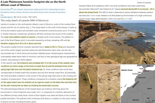
Human footprints embedded in rock that used to be a sand beach at the limit of the seashore’s “swash flow” and high tide lie 20 to 30 meters above the present sea level. The footprints are dated to ~90,000 years ago. [emphasis, links added]
It is estimated that sea levels were about 6 to 9 meters higher than today globally during the last interglacial (~130,000 to 115,000 years ago) when CO2 supposedly peaked at 275 ppm (Sommers et al., 2022).
Evidence along the coasts of North Africa (Morocco) suggests that sea levels were “20 m above the present level” about 95,000 years ago (MIS 5c).
This is consistent with a new study that reports human footprints embedded and preserved in a rocky beach “20 to 30m above sea level” can be dated to 90.3 ±7.6 thousand years ago [ to 97.9 thousand years].

The water limit, or shoreline, very likely reached this elevation at that time, as the requisite conditions for “salt crusting,” the preservation of footprints, involve a location at “the landward limits of the spring high tidal zone” and at the “limits of swash flow”.
Interestingly, this same Moroccan region’s shoreline in recent decades has been stable, advancing seaward at a rate of +0.89 m per year (Amara Zenati et al., 2024).
This is inconsistent with the viewpoint that sea level rise is poised to flood the Earth’s coasts and shrink its shorelines.
And coastal expansion isn’t just a local phenomenon. Globally, shorelines have been advancing seaward at a rate of +0.26 m per year since the 1980s, as, despite sea level rise, the “global coastline is prograding” (Mao et al., 2021).
Read more at No Tricks Zone


30 meters = 100+ feet?
Proves there was a Great Flood and Noah was real and he did Build the Ark which is s till up there on Mt. Arat