
in the background (AI-generated).
Antarctica is commonly perceived as a vast expanse of glacial ice. The typical image is that of a researcher enduring severe winds and challenging conditions. However, few consider that this frozen, immense continent contains active volcanic systems, rock strata emitting considerable geothermal heat beneath the glaciers, thousands of earthquakes, or subterranean chambers of molten magma influencing its geological uplift.
The impact of geological forces on virtually every facet of the Antarctic continent is often significantly underestimated. For instance, Mount Erebus, as referenced above, stands at 12,441 feet on Antarctica’s western edge (Figure 1). It has remained active since 1972 and has experienced multiple significant eruptions over the past seventy years.
Understanding what forces control the extent, amount, and timing of Antarctica’s glacial and sea melting is important because it impacts many aspects of the climate and climate-related phenomena of our planet.
Hidden Power of Geological Forces
If superheated, chemically reactive gases and fluids from geological activity have major impacts on Antarctica, why have these effects gone unnoticed? The key reasons are remoteness, interpretation bias, and limited monitoring.
Remoteness
Where are remote areas on Earth? Oceans cover 71% of Earth’s surface at an average depth of 14,000 feet, while polar ice sheets cover 9% (6,200 feet thick), and sea ice covers 5%.
This makes 85% of our planet remote.
Antarctica’s remoteness poses major challenges for research, especially in geology. Its glacial ice sheet averages a mile thick, making drilling expensive and rare. Surrounding sea ice stretches over 10,000 miles, further limiting access to exposed rock.
Beneath the ice, high mountains and deep valleys complicate geological understanding—so only general descriptions exist, restricting insight into Antarctica’s geological forces.
Interpretation Bias
Scientists often begin research with preconceived ideas about what causes an event or phenomenon and look for data that supports these beliefs. Over time, this tendency to interpret new information in favor of original theories is known as interpretation bias; when related to atmospheric phenomena, it’s called atmospheric bias.
Many Antarctic studies have attributed most events to climate change, potentially overlooking the impact of geological forces.
Insufficient Monitoring
The main reason geological processes in Antarctica are not well understood is insufficient monitoring.
To accurately assess the impact of these forces on Antarctica’s glacial ice, sea ice, oceans, and heat emissions from rock layers, enhancing current monitoring systems is essential.
Such improved systems should be able to record the frequency, duration, and magnitude of changes in these characteristics.
Frequency
Geological features such as fault segments, volcanoes, and hydrothermal vent complexes operate intermittently, emitting heat and chemicals when active. Tracking the on-and-off periods allows comparison between emissions from geological sources and variations in glacial ice, sea ice, oceans, and atmosphere.
Duration
The length of time geological features release gases, fluids, and chemicals before becoming inactive is important for determining total emissions. Emission durations differ significantly among features.
Some remain active for thousands of years before ceasing activity, while others previously considered extinct may resume activity unexpectedly.
Volume
Many studies focus on the amount of heat emitted from rock layers beneath Antarctica’s ice sheet. Increased data collection has shown that the region’s heat output is greater than earlier estimates.
The identification of areas with higher-than-average emissions is relevant for evaluating melt rates.
These rates can improve the understanding of factors contributing to Antarctic ice melt. Volcanic activity tends to produce higher melting rates compared to other mechanisms, as illustrated by the Larsen Volcanic Peninsula.

If you doubt that Antarctica’s geology influences the continent, consider two of the examples shown in Figure 2, the South Shetland Islands and the Larsen Volcanic Plateau.
Both of these areas are part of a giant fault complex termed the West Antarctic Rift, the final piece of the most active geological feature on Earth, the Pacific Ring of Fire.
South Shetland Islands

The South Shetland Islands constitute a 450-mile-long and 50-mile-wide chain that forms part of the West Antarctic Rift System (Figure 2). The islands host nine terrestrial volcanoes, one submarine volcano, and several hydrothermal vents located on the ocean floor, all classified as “Active Category” geological features.
This designation indicates they may erupt, are currently exhibiting mild eruptive activity, or are emitting chemically enriched fluids into the atmosphere or surrounding waters.
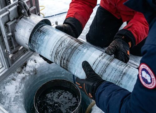
Deception Volcano [pictured below] on the South Shetland Islands, shown in Figure 3, experienced a significant eruption nearly 4,000 years ago, impacting the global climate for up to twelve months.

The eruption resulted in the removal of the summit, forming a 2.5-mile-wide ocean bay that is now connected to the open sea. Since then, smaller volcanoes along the remaining caldera rim have erupted ten times from 1827 to 1995.
The bay floor contains an estimated five geysers, which release heated fluids that keep much of the bay ice-free and, in certain locations, raise water temperatures to sauna-like levels.
Between August and November 2020, tectonic faults associated with the formation of the South Shetland Islands generated approximately 85,000 earthquakes. Notably, the submarine volcano ORCA exhibited heightened volcanic activity before, during, and after this seismic event.
The ongoing geological activity observed throughout the region is probably driven by the persistent ascent of an extensive subterranean magma chamber.
Larsen Volcanic Peninsula

The Larsen Volcanic Peninsula is a west-to-east-oriented area measuring approximately 50 miles in length and 10 miles in width, located in the northern part of the West Antarctica Rift (Figure 4).
It contains sixteen small volcanoes that are similar in size and shape, with minimal or no ice present on their flanks. These features suggest that the volcanoes were formed by the emergence of a large molten lava chamber, which may still be situated beneath them.
Historical records from early explorers mention observations of volcanic ash on glacial ice, while recent aerial surveys by University of Chile geologists noted fresh black volcanic ash on the ice sheet, indicating ongoing volcanic activity.
Changes in the surrounding sea ice of the Larsen Volcanic Peninsula have been observed over the past fifty years. Before 1986, sea ice encircled the entire peninsula and extended into the ocean. Starting in 1986, the edge of the sea ice attached to the peninsula began to melt, gradually increasing the ice-free area outward from all sides of the peninsula.
This pattern differs from typical sea ice melting, which usually occurs from the open ocean toward land. The melting pattern near the Larsen Volcanic Peninsula is likely influenced by sustained heat emissions from the lava chamber beneath the region.

Heat from the seafloor flanks of land volcanoes and known ocean floor volcanoes in the Larsen Volcanic Plateau are the cause of sea ice melting in the plateau area. Researchers and mariners identified what I see as a heat-emitting ocean floor volcano located offshore of the Larsen Volcanic Plateau, as quoted below.
“NSF is an independent federal agency that supports fundamental research and education across all fields of science and engineering, with an annual budget of nearly $5.58 billion. NSF manages the U.S. Antarctic Program, which coordinates U.S. scientific research on the southernmost continent and in the Southern Ocean. Evidence of the volcano came as an unintended bonus from a research plan to investigate why a massive ice sheet, known as the Larsen B, collapsed and broke up several years ago. Scientists hope to understand whether such a collapse is unique or part of a cycle that extends over hundreds of thousands of years. Scientific evidence the team collected also corroborates mariners’ reports of discolored water in the area, which is consistent with an active volcano” (National Science Foundation 5-31-2004).
The location of sea ice melting in waters adjacent to the Larsen Volcanic Plateau has significantly changed during the last fifty years. Figure 5 illustrates the time-progressive melting pattern.
The melting begins in areas immediately adjacent to all sides of the peninsula. Through time, the sea ice melting area spreads outward in the same pattern as the initial melting phase. In this fashion, the sea ice continues outward.
This process does not fit with melting that is the result of uniform global warming. A more plausible explanation is that bedrock heat flow emanating from the plateau’s lavas, cinder cones, flanks of the cinder cones that extend into the ocean, and ocean floor volcanoes are acting to melt the overlying sea ice.
Summary
The continent of Antarctica is of greater area than the United States of America. This includes the states of Alaska and Hawaii.
Understanding what forces influence the melting of its glacial and sea ice is of great importance because it helps plan the future consequences of this melting. The impact that geological activity has on the melting has been significantly underestimated.
Biography
James Edward Kamis is a retired geologist with nearly five decades of hands-on experience studying Earth’s forces. With a B.S. in Geology from Northern Illinois University (1973) and an M.S. from Idaho State University (1976), he has spent his career uncovering how geological forces shape—and sometimes drive—climate and climate events. Kamis shares his insights in detail at Plate Climatology Theory and in his latest book, Geological Impacts on Climate.


I wonder about the active Hudson Mountain volcanic field at the P.I.G. and the huge volcanic cones up from Thwaites? Isn’t that ash and melting that I see on Google Earth? Why seldom mentioned anywhere? Occam’s Razor no longer valid in science?
CO2 principally emits IR radiation that is equivalent to -80 deg C. As nothing on Earth’s surface is colder than that, this IR cannot be absorbed (this energy levels are already full) and is reflected back upward to space. Physicists have been unable too make CO2 warm anything. In fact, it appears to be the world’s best refrigerant that is also cheap, stable and nontoxic. New skating ri inks are using CO2 and Mercedes is using CO2 A/C. CO2 in the atmosphere is constantly trying to cool the planet. There is no such thing as a greenhouse effect, which is a disproven hypothesis by Arrhenius and junk science promulgated to demonize CO2 and human activities.
only a tiny amount of antarctica ice melts per year …. so small that it is below the margin of error in the estimates of the total ice mass … the melting is entirely caused by heat from the oceans because antarctica itself is too cold to melt any ice … the melting is almost entirely in the peninsula area from the oceans and several ice shelves with the oceans underneath them … the source of the ocean heat is either underseas volcanoes & vents or ocean currents going south from the equator (Antarctic Circumpolar Current) … most of antarctica has a permanent temperature inversion which causes a negative greenhouse effect, which causes cooling rather than warming … that negative greenhouse effect is a symptom of increasing CO2 emissions and the reason that antarctica stays so cold … 90% of the land ice on earth is on antarctica and almost none of that ice will melt in our lifetime … at the current antarctica ice rate melt rate it would take 160,000 years for all the ice to melt and that would only happen if the current interglacial lasted 160,000 years … our current interglacial is 12,000 years old is not likely to last more than 20,000 years … but Earth’s current orbit is in a low-eccentricity phase (more circular), which mimics a long interglacial period from about 400,000 years ago that lasted nearly 30,000 years.