 Three weeks ago, a major cold snap and series of winter storms enveloped the southern plains and parts of the Mississippi River Valley, sending temperatures below zero as far south as central Texas.
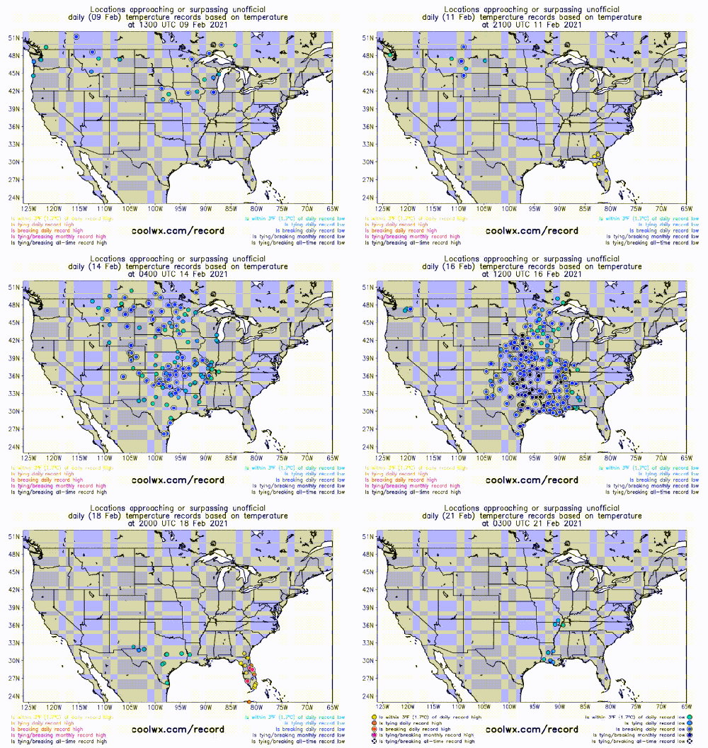
According to NOAANCEI, a total of 8,632 daily record low temperatures — including both maximums and minimums — were set or tied from February 10-20, as opposed to only 262 daily warm records.¹
Additionally, a whopping 693 monthly record lows were set, 199 of which were all-time record lows.
According to the NOAA Weather Prediction Center, over 30% of all of the official weather stations in the United States set at least a record low maximum temperatures between February 14 and 16.
Without a doubt, this was the coldest 10-day period that this part of the country had experienced in over a century. The animation below conveys just how widespread the cold was between February 10 and 20 (Figure 1).²

While no statewide records were broken, some of the records that were reported were quite shocking, to say the least.
The two coldest days were Monday, February 15, and Tuesday, February 16, where temperatures were some 40-50°F below average across Oklahoma and Texas.
Between February 11 and 18, temperatures across much of the Heartland averaged some 30°F below average (Figure 2).³ Temperatures this cold for such a sustained period can lower the monthly and seasonal average by a wide margin.

On Monday, February 15, Oklahoma City only rose to 4°F (-15.6°C), which was colder than the daily record low of 7°F (-13.9°C) set in 1909!⁴
San Angelo, Texas, dipped to a bone-chilling -1°F (-18.3°C), which tied with December 29, 1983, and February 2, 1985, for the city’s second-coldest temperature, only behind the reading of -4°F (-20°C) set on December 23, 1989.⁴
That was also the only subzero reading for the date, smashing the old record of 16°F (-8.9°C) from 1909.⁴ Houston, Texas, dipped to 16°F on Monday the 15, which was their coldest temperature since December 24, 1989, when it plunged to 11°F (-11.7°C).⁴
That also broke the old daily record of 18°F (-7.8°C) from 1918.⁴ Kansas City, Missouri, plunged down to -10°F (-23.3°C), breaking the old record of -6°F (-21.1°C) from 1936, while the high of -1°F smashed the old record of 8°F (-13.3°C) from 1900.⁴
According to the local National Weather Service office, a wind chill of -32°F (-35.6°C) was recorded, the coldest wind chill there since 1989.
The following morning, Tuesday, February 16, even more, notable record lows were set. Oklahoma City once again set a record low, this time falling to a jaw-dropping -14°F (-25.6°C), which not only obliterated the old daily record of 4°F (-15.6°C) set in 1903, it was the coldest reading there in over 120 years, only second to the -17°F (-27.2°C) recorded on February 12, 1899.⁴
Oklahoma City also recorded its longest stretch of temperatures at or below 20°F (-6.7°C), at 210 consecutive hours, surpassing 1983.³ Meanwhile, Tulsa dropped to -13°F (-25°C), tying the city’s coldest temperature on record, originally set on January 12, 1918.⁴
Dallas, Texas, even dipped to -2°F (-18.9°C), which matched January 31, 1949, for the second-coldest temperature ever recorded there, just behind February 12, 1899, when it dipped to a bone-chilling -8°F (-22.2°C).⁴
Tyler, Texas, broke their all-time coldest temperature of -3°F (-19.4°C) from January 18, 1930, dipping to six below zero.⁴ Hastings, Nebraska, tied their all-time coldest temperature of -30°F (-34.4°C), originally set on January 12, 1912.⁴
It also obliterated the old daily record low of -13°F set in 1979.⁴ In Arkansas, Fayetteville fell to -20°F (-28.9°C), which not only annihilated the old record of 7°F from both 1958 and 2007, it was their all-time coldest temperature, and only nine degrees short of the statewide record set on February 13, 1905, in Gravette.⁴
Perhaps the most impressive record that was set was in Bottineau, North Dakota, approximately ten miles from the Canadian border.
On the morning of February 13, the mercury dove to an incomprehensible -51°F (-46.1°C), which not only crushed the previous daily record of -37°F (-38.3°C) from 1936, it also broke the town’s prior all-time record low of -50°F (-45.6°C) set on February 3, 1893, a record that stood for over 128 years!⁴
This reading was only nine degrees off the statewide record, set on February 15, 1936, in Parshall.⁴ Other impressive readings were temperatures as low as minus 20° as far south as northern Texas.
Now that we have flipped the calendar to March, to really shed some light on how large of an impression the Arctic outbreak had on the monthly outcome, last month was the coldest by departure from average in the Continental United States since December 2000 (Figure 3) and third coldest since December 1989.

Major cold snaps that impact the southern plains all share similar characteristics with respect to their meteorological evolution.
While the event itself was arguably predictable with moderate confidence as early as two weeks out, something my friend meteorologist Joe Bastardi over at WeatherBELL.com was very bullish — and ultimately correct — on from over ten days out, the threat for such cold became elevated within weeks following the sudden stratospheric warming event that was the primary cause of the stratospheric polar vortex (SPV) displacement.
The term polar vortex has become a part of everyday vocabulary after broadcast meteorologists and journalists began using it during the winter of 2013-14.
What many people don’t know is that each hemisphere actually has two polar vortices: the stratospheric and its tropospheric counterpart (Waugh et al. 2017).⁵
The knowledge of a stratospheric circulation has been known since the 1940s and has been referred to as the polar vortex since at least the 1950s (e.g. Brasefield 1950, Palmer 1959).⁶ ⁷
While the tropospheric polar vortex (TPV) exists all year, the stratospheric circulation only exists from mid-late autumn through mid-late spring (keep in mind seasons are opposite, respective of which hemisphere) (e.g. Waugh et al. 2017).⁵
It forms as thermal gradients tighten between the mid-latitudes and poles, which occurs due to a lack of solar heating (e.g. Waugh et al. 2017).⁵
As the air becomes colder, the temperature difference (gradient) between the poles and mid-latitudes increases, which causes westerly winds in the upper levels of the atmosphere to begin cranking in an attempt to balance the energy differences.
The SPV is generally circular and fairly symmetrical in nature, unlike the TPV. This is because land-sea contrasts and topographic influences aren’t as pronounced in the stratosphere.
The TPV, like its stratospheric counterpart, is strongest during the winter and is weakest during summer and exists due to thermal gradients (e.g. Waugh et al. 2017).⁵
Planetary Rossby waves, which form in highly baroclinic environments, if strong enough, can affect the symmetry and structure of the SPV (e.g. Waugh et al. 2017).⁵
Rossby waves strong enough to propagate upward into the stratosphere and cause a deceleration or even reversal in the westerlies typically form as air flows over mountains and rough terrain (e.g. Charney and Drazin 1961 and Limpasuvan et al. 2004).⁸ ⁹
Deceleration or reversal in the westerlies surrounding the polar vortex often initiates a sudden stratospheric warming (SSW) event, which can cause the polar vortex to either be displaced or even split into two or three vortices.
If either of those two things occurs, that energy propagates down into the troposphere and subsequently causes the TPV to do the same.
You can see the distinct differences between the two vortices in the schematic diagram below from Figure 1 in Waugh et al. 2017 (Figure 4).

Sudden stratospheric warming events, by and large, occur much more frequently in the Northern Hemisphere than in the southern, simply because there is more land-sea contrasts and mountainous terrain in North America than in Antarctica.
In fact, there have been only two documented occurrences of it occurring over Antarctica; once in 2002 and more recently in 2019. While major stratospheric warming events don’t occur every year, it is not uncommon for them to occur every 2-3 years.
As I mentioned above, we did observe a sudden stratospheric warming event back in early January. As early as mid-December, I highlighted this as something that could very likely occur in early January.
A time-based vertical cross-section of atmospheric temperature anomalies from the surface to the very top of the atmosphere averaged along 60°-90°N latitude is shown below (Figure 5). Time is on the x-axis while air pressure (hPa) is plotted along the y-axis alongside height in altitude (km).
Pressure levels are plotted because air pressure decreases exponentially with altitude. 1000 hPa of air pressure, for instance, is on average, found at the surface and the average air pressure of 500 hPa is found at approximately 5.4 km.
The shaded areas within the plot are temperature anomalies with respect to time and altitude.
The early January warming in the stratosphere is clearly visible on the far upper left, as denoted by the deep orange and red shading, and as time progresses, that energy transfers down to the mid-levels of the atmosphere and surface, which reinforced the already-existing high-latitude blocking pattern, causing the TPV to become displaced into Eurasia in mid-late January.

While not all sudden stratospheric warming events cause a disruption to both the stratospheric and tropospheric polar vortices, there is an enhanced risk for severe cold air outbreaks in the mid-latitudes beginning around two weeks after the event if it does.
In mid-January, many weather enthusiasts and meteorologists declared winter to be a bust, yet I alerted my followers that it may take an additional 2-4 weeks before we begin to see the effects of the TPV displacement into Eurasia here in the United States.
Typically, but not always, when a split or displacement favors Europe initially, that cold air will come into North America later in the winter, which is why I highlighted late-January through mid-February as a prime time for winter to make a roaring comeback.
However, to get that cold air into North America and down into the Lower 48, there needs to be cross-polar flow. Cross-polar flow occurs when an area of higher heights known as a ridge builds in over Alaska, which causes the jet stream to meander around the ridge over Alaska, through the Arctic, then dip south into North America bringing with it true Arctic air out of Siberia.
Since Arctic air masses are very cold, they are also very dense. Cold air is denser than warm air, which causes it to sink to the surface. This greater mass of air at the surface creates a surface anticyclone with an upper level low aloft; this is also known as a cold-core high (Figure 6).¹⁰
Because cold air contracts and is dense, thickness values between height contours are far lower than in warm air masses associated with warm-core highs (ridges). High-pressure systems, regardless of their nature, are associated with little to no wind at the surface as air diverges away from the center.
This lack of wind prevents the mixing of air, which allows temperatures to either be extremely cold or extremely hot. This tidbit of information will be useful later.

Throughout much of January, jet stream flow was very progressive and zonal over the North Pacific. This was largely due to La Niña.
Progressive flow over the North Pacific inhibits upper-level convergence over the West Coast of North America from developing a ridge to slow down the flow and change the jet stream configuration. As a result, the entire continent was flooded with mild Pacific air. However, by mid-February, changes were a-comin’.
The evolution of the recent cold snap was very similar to the setups which caused other historical cold spells across the southern plains (Figure 7).
For purposes of this article, we’re going to make a comparison to the deep freezes of December 1983, February 1985, and December 1989.
Shown below from left to right in chronological order are the synoptic-scale setups for each outbreak, with the recently expired one on the far right.
The top panel conveys 500 MB heights on the day leading up to the beginning of the Arctic outbreaks, while the bottom panel conveys surface mean sea-level air pressure (MSLP).
As clearly shown in each picture in the top panel, a ridge developed in the jet stream (denoted by the black H) over Alaska. Some ridging over Northern Canada forced the tropospheric polar vortex (TPV) south into the Prairies bringing with it very cold air.
The upper-level low associated with the TPV means that there is a cold-core high at the surface. As the TPV rotated about itself, the Arctic surface anticyclone dived south into the Rockies and Heartland before migrating south into Lone Star country.
During this go-round, several low-pressure areas that developed along the cold front dropped considerable amounts of snow and freezing rain across Texas in the span of ten days.

The Texas Energy Disaster
Incredibly cold air combined with snowfall and freezing rain impacting regions that infrequently observe such conditions can only lead to disaster to the energy grid and infrastructure only built to local building codes, especially if a significant percentage of that energy is supplied by unsustainable sources.
This is exactly what occurred in Texas three weeks ago. The majority of businesses, schools, places of worship, and homes there are built to be resilient to incredibly hot summertime temperatures that engulf the state in a bake fest, not winter storms and extremely cold temperatures.
To vividly describe all of the damage to infrastructure and to tally the loss of life and property would be essentially impossible. Both the major winter storm and Arctic outbreak cost $195 billion in damage, topping Hurricanes Harvey for the costliest natural disaster in U.S. history. [The cost of natural disasters has actually fallen as a percentage of economic output since 1990. –CCD Ed.]
As the cold settled in and the energy grid collapsed, pipes inside homes and businesses froze, contracted, and burst to release pressure, flooding buildings with insane amounts of water. Many of those who couldn’t venture elsewhere to seek warmth literally froze to death in their homes.
As usual, trying to have a coherent discussion with someone about what actually happened using science, common sense, and logical reasoning is quite the challenge. You can’t get a single word in without someone viewing the issue through their political ideology lenses.
Democrats are blaming climate change (more on that nonsense later) and shortages in natural gas, while Republicans blame the loss of renewable wind power on the crisis.
While there is some truth to both, it is a complex issue and there isn’t blame to place on any specific person or thing. So, what actually happened to cause the energy grid to fail?
The first thing we need to look at is what the main sources of energy are in Texas. According to last year’s ECROT Texas Fuel Mix Report (Figure 8), wind energy accounts for 23%, overtaking coal as the second most prominent energy source within the state.¹¹
Natural gas is still the largest source of energy in Texas, comprising 46% of the grid.¹¹ Progressive politicians in Texas have been encouraging the development of wind turbines across the western half of the state as well as along the Gulf Coast for years.
As such, wind power is the fastest-growing source of energy in Texas, as it has risen from accounting for 11% of the state’s energy supply in 2015 to 25% so far in 2021.¹¹ The ever-increasing reliance on wind energy means that there is steadily less demand from fossil fuels like natural gas, coal, and nuclear with each passing year.

The push for wind energy ultimately has nothing to do with wind energy being cleaner, rather it’s because the renewable energy industry is being used by the government to take in billions of dollars in taxpayer money annually.
In Texas alone, both the local and federal government combined have collected over $80 billion in solar and wind subsidies over the last 15 years.¹²
Like the fossil fuel industry, the renewable energy industry should be able to mostly thrive on its own without taxpayer money, but that’s if it were affordable, reliable, and efficient on a large scale.
Without tax dollars going toward subsidies by means of, to put it honestly, government theft, the wind industry in Texas would be minuscule compared to the 23-25% it currently supplies to the state.
So, with that in mind, let’s take a closer look at what happened in Texas…
Read rest at Chris Martz Weather
Chris Martz is a soon-to-be meteorologist and runs the website Awesome Weather Facts and Chris Martz Weather. He regularly writes about the climate, our weather, and forecasting.


FEB. 15, 2021 2 million Texas households without power as massive winter storm drives demand for electricity
Some utility companies that deliver electricity to Texans are telling customers to expect power outages through Monday night and potentially into Tuesday.
https://www.texastribune.org/2021/02/15/rolling-blackouts-texas/
Feb 19, 2021 Wind And Solar Reliance Failed Texas
We need to let the free market develop and allocate our energy, NOT politicians!
https://youtu.be/AMfrz_BuP8M
And they told us it would never ever snow again its just that Texas chose to Go Green and depend upon Wind Energy But just think that under t he Green New Scam(Deal)this could happen to the whole nation